Low Flow Monitoring in the South Fork Eel River

By Salmonid Restoration Federation
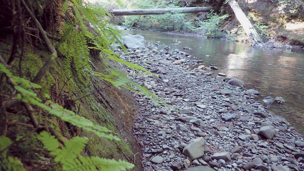
The South Fork Eel River provides critical habitat for coho salmon and other aquatic species including steelhead, red-tailed frogs, lamprey, and Pacific giant salamanders. Juvenile salmon utilize different parts of the watershed from the tributaries to the mainstem during various stages of their life cycle. The forested tributaries of the South Fork Eel provide sheltered refugia for imperiled species like coho salmon that need cool, clean water particularly when they are juveniles. Many of the tributaries of the South Fork Eel suffer from the legacy land use impacts of logging, ranching, and unregulated cannabis production. Even now, the post-legalization environment presents many questions about water management, carrying capacity, and how to balance economic drivers and environmental needs for
endangered species.
Redwood Creek and Sproul Creek, A Tale of Two Tributaries
The South Fork Eel is considered one of five priority watersheds in the state for flow enhancement efforts. Even though this region receives some of the highest precipitation in the state, there is relatively little municipal infrastructure available to allow for flow releases to meet the needs of coho salmon. This region is mountainous and has dozens of populated tributaries including Redwood and Sproul Creek in Southern Humboldt County. Both of these watersheds are considered priority watersheds because despite current land use practices, the tributaries still provide habitat and have intrinsic recovery potential. This potential can only be realized through coordinated and strategic water management actions that engage the community and address the effects of climate change and longer dry seasons.
SRF has been conducting low-flow monitoring in Redwood Creek since 2013 and in Sproul Creek since 2019. Low flow monitoring helps us understand the summer flow conditions when cool instream flows are most critical for juvenile salmonids and when human water use is at its highest. Peak demand often coincides with the hottest days of summer when juvenile salmon are most vulnerable to high water temperatures. The longevity of our monitoring effort means that we have collected data during the extended drought as well as recent years when there were unusually late spring rains. Throughout the monitoring effort, SRF has witnessed creeks in Redwood Creek becoming disconnected by mid-summer. Redwood and Sproul Creeks offer a lot of interesting comparisons since they are adjacent near the headwaters yet have different landowner patterns and hydrology.
Redwood Creek is a densely populated watershed with approximately 400 parcels, hundreds of residents, and countless water diversions for legal and unregulated cannabis cultivation as well as small domestic use and homestead gardens. Comparatively, Sproul Creek has significantly less consumptive human water use with large tracts of the watershed in private ownership including the Marshall and Wagner ranches and the former Barnum timberland that is now owned by Green Diamond
Timber Company.
Both tributaries are considered significant for coho salmon recovery in the South Fork Eel and similarly the SF Eel is key to the overall survival of coho salmon in the Southern Oregon/Northern California Coast (SONCC) Evolutionary Significant Unit (ESU). According to the SHaRP process (Salmon Habitat and Restoration Priorities) spearheaded by NOAA Fisheries, Sproul Creek is considered one of the highest priority tributaries in the South Fork Eel River watershed for biological importance. Sproul Creek ranked high for habitat condition as well as “optimism and potential” for recovery.
Last year, SRF was able to monitor the sites that California Trout had previously established in Sproul Creek. SRF and CalTrout began their independent flow studies at the same time with the understanding that it would be beneficial to do a paired study to understand flow patterns in sub-watersheds with
and without extensive human consumptive use (Redwood Creek and Sproul Creek respectively).
Already, it is clear that 2019 and 2020 are dramatically different water years. In 2019, rain was plentiful and Southern Humboldt received late spring rainfall, as a result flows in Lower Sproul Creek were 3,000 gallons per minute (gpm) on July 8, 2019 and only 1,700gpm on July 3, 2020. Similarly, mainstem Redwood Creek flows were 2,500gpm in mid-June and only 1,200gpm by July 3. At the rate that flows are diminishing, it is likely that several tributaries will be precariously low by August.
SRF is working closely with Stillwater Sciences, a leading consulting firm on the North Coast that is already actively working in the South Fork Eel on restoration and flow enhancement projects. SRF and Stillwater Sciences have been restoration partners for several years and their engineers and geologists have already completed a feasibility study for a portion of Redwood Creek (Miller Creek and a segment of the mainstem). Currently, the Stillwater Sciences project team is exploring flow enhancement opportunities in the remainder of Redwood Creek and Sproul Creek.
This project will create an implementable plan for improving dry season streamflows in Sproul Creek that will support recovery of threatened and endangered steelhead and salmon within the sub-basin. Since instream flows and cool water temperatures are critical for juvenile salmonids to survive the hot summer months, SRF is utilizing multiple approaches to keep residents informed about current flow conditions. Especially during COVID-19 when it is not feasible to host community meetings, we are wanting to make information available in various platforms including road signs, radio, webpages, and Facebook.
To help residents be aware of current flows, SRF has maintained a large painted sign on the Briceland Road that is updated after monitoring to indicate the flow level. Additionally, there is an interactive graph on the SRF website for both Redwood and Sproul Creeks (http://www.calsalmon.org/programs/redwood-creek-low-flow-monitoring) that shows the dates and flows for each monitoring visit as well as comparative graphs for previous monitoring years. (https://www.calsalmon.org/programs/sproul-creek-low-flow-monitoring)
The idea is that if water users understand the current flows they will moderate their diversion amount or schedule. Many residents have built sufficient water storage to voluntarily forbear from diverting water during the dry summer months when salmon are most vulnerable to low flows and high water temperatures. As part of this planning project, SRF is also identifying participating landowners to partner with to design winter water storage and pond projects that cumulatively could enhance flows in Redwood Creek or Sproul Creek. To learn more about this project, see current flows, or educational presentations from the 2019 Pond Planning and Groundwater Recharge workshop, please visit www.calsalmon.org/programs/redwood-creek-low-flow-monitoring
For more information:
calsalmon.org