Action Plan for Tenmile Creek Brings Restoration into Focus

Comments on Action Plan due July 22
By Eel River Recovery Project
Since August 2018, the Eel River Recovery Project (ERRP) has been working on the Tenmile Creek Conservation and Restoration Pilot Project funded by the California State Coastal Conservancy (SCC) using Prop 1 grant funds. The project aims to fix riparian zones, control erosion, and plan for water conservation in two important fish-producing tributaries, Streeter Creek and Big Rock Creek. The culminating product of the grant is the Tenmile Creek Watershed Conservation and Restoration Action Plan, which is available for review here. (Comments accepted until July 22. Send your comments to [email protected].)
Tenmile Creek is a 65-square-mile watershed in northern Mendocino that includes the town of Laytonville, comprising roughly half of the upper South Fork Eel River watershed above the creek’s convergence with the river. The low gradient of Tenmile Creek would have made it historically important for coho salmon, but they are present now at only very low levels. Chinook salmon and steelhead runs in the basin can still be strong in some years, but excess sediment and altered flow regimes are stressing both populations. The Action Plan not only characterizes salmonid populations of Tenmile Creek, it describes other fish species and their status and how each can be used as an indicator of aquatic environmental quality.
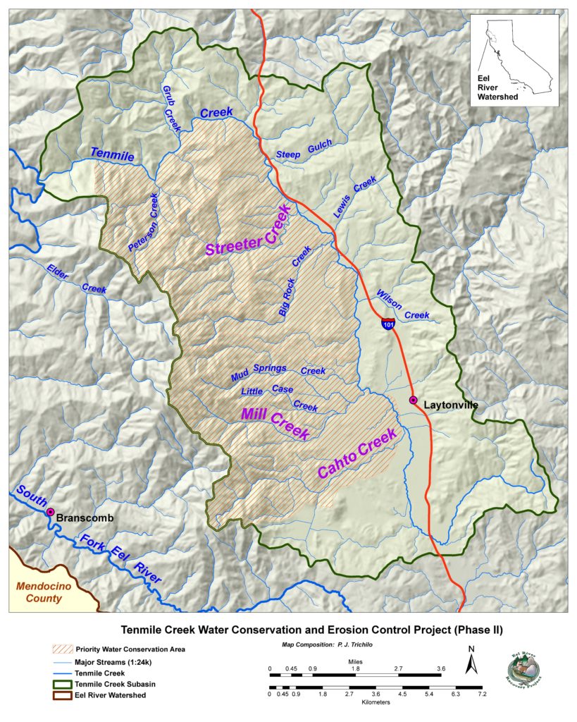
A geologic fault running down the middle of the Tenmile Creek watershed from north to south divides the Coast Range from the Central Belt Mélange Terrain, which gives rise to grasslands in the eastern part of the watershed. These areas are particularly susceptible to gully erosion if roads are constructed and downspouts from road drainage are not properly armored. To the west, coniferous forest dominated by Douglas-fir and Ponderosa pine prevails, while oak woodlands predominate east of the fault.
Thomas Gast and Associates Environmental Consultants studied water supply in tributaries Streeter and Big Rock Creeks and compared the numbers to the control stream Elder Creek using a U.S. Environmental Protection Agency model called VELMA (Visualizing Ecosystem Land Management Assessments) that can utilize both spatial and tabular data. Patterns of flow of Streeter and Big Rock Creeks did not indicate summer water withdrawals or substantiate the hypothesis that these streams are being dried up by agricultural use.
Instead, flow impairment in Streeter and Big Rock Creeks appears to be driven by increased evapotranspiration of the second-growth forest 40–60 years after post-WW II logging, as well as the vegetation shift of Douglas-firs over-topping oaks. Since oaks use less water than the Douglas-fir, this unwanted succession decreases base-flows. ERRP obtained a North Coast Resource Partnership grant to begin forest health planning in July 2020. We will work in cooperation with the Tenmile Creek Watershed Council, which has plans to focus on forest health and to bring in resources for implementation to reduce fire risk, improve base-flows, and create jobs.
The Action Plan defines a Priority Water Conservation Area (PWCA) in the western part of the Tenmile Creek basin, where partnerships will be sought with landowners who want additional water storage to enable forbearance. The report discusses groundwater issues, including the connection between surface water and groundwater, and points out potential conflicts that could arise in the future. The SCC Prop 1 Phase II grant applied for by ERRP in April 2020 would fund such a surface and groundwater interaction study, assist residents of the PWCA, and secure funding for planning and permitting of water storage facilities for a large organic farm and Camp Winnarainbow on the Black Oak Ranch.
ERRP will be accepting comments on the Action Plan until Wednesday, July 22. Copies of the Action Plan are available online at www.eelriverrecovery.org and will be made available in hard copy at the Laytonville County Water District office. Call (707) 223-7200 for more information.
For more information:
www.eelriverrecovery.org